And for your next project....http://www.bbc.co.uk/news/technology-15790088
PICAXE handling GPS for robot boat
- Thread starter Robin Lovelock
- Start date
Robin Lovelock
Senior Member
Thanks Martin and MFB. You are right, of course, Martin - I just checked with a simple test program. Good to know that I will not need to be as super-cautious with such picaxe arithmetic. Let me check that link, MFB .... Ah yes - this wave sufing sub approach has been discussed on the Microtransat robot boat forum (follow links from my page - it's an emailing list rather than a forum). No, I think I'll stay on the surface for now - Snoopy has already had plenty of sub-surface adventures - checkout the "Snoopy Sails!" video ")
Meanwhile, little 3ft boat 6, did a brilliant sail a week ago, in little or no wind, but still completed the Bray Lake course, from base, through waypoints A, B, C, D and back to within 2 metres of base - in only 15 minutes. We are waiting for a day with at least 5 to 10 knots of wind - it should then complete in nearer 5 to 10 minutes. Boat 7 is almost ready - being 4 foot long and carrying 5 solar panels. The bigger hull should cope with stronger winds than boat 6. We will also do some tests - probably with boat 6 - with the autopilot not knowing wind direction: it may work well enough - and give a much simpler and reliable solution than using our wind direction sensor.
Robin
www.gpss.co.uk/autop.htm
Robin Lovelock
Senior Member
Hi Folks. I have another question you may help me with - use of the # qualifier in SERIN.
From picaxe documentation: QUOTE: Variable(s) - receive the result(s) (0-255). Optional #'s are for inputting ASCII decimal numbers into variables, rather than raw characters. UNQUOTE.
I've been using this for some time, with success, within the simple GPS->PICAXE->rudder servo auto pilot that has been steering my little robot sailing boats around the Bray Lake test course. You can see my recent updates on the page www.gpss.co.uk/autop.htm
Here is the section of code that uses # where it reads part of the GPS message holding speed and direction of movement (heading):
The GPS heading value is read into w2 and, later in the program, is used to calculate how to steer the boat onto the correct target heading, towards the current destination waypoint.
and here are three examples of GPS data - sadly different between different GPS type:
But my existing code works just fine - since it just needs the GPS heading. 134, 022, or 191 in the above examples.
Now I want to modify the program so that it also extracts the speed - in the earlier field. It does not need to be more accurate than 0.1 knots, and I can probably assume the boat will be slower than 10 knots. i.e. If I scaled it to units of 0.1 knots, that would be 12 from W,1.25,134.28, or 17 from W,001.7,022.4, in the above examples.
It would be much easier if all sources of this data gave exactly the same output.
I could not find more detailed documentation on the # qualifier than that earlier.
If I used it here, I guess it would not give me more than the integer preceeding the decimal point ?
i.e. 1 in the above examples.
Why would I like to extract speed ? Because it's just possible that this could avoid needing to add a wind direction sensor - another source of unreliability across the Atlantic. It's just possible that the software might recognize the boat trying to sail too close to the wind (getting "into irons") from the speed - typically between 0.5 knots and maybe 5.0 knots if very lucky.
But before I can test this on the water, I need to find a simple way of extracting the speed - for any of the GPS we are using in our prototypes.
Robin
www.gpss.co.uk
p.s. no reply yet, and nothing found about # in serin in documentation or other threads - so I hope I don't have to resort to "suck it and see"
Maybe this might work ?
The code above seems to work - based on "suck it aand see"
1st January 2012: Happy New Year ! I've updated the "Snoopy Sails!" video on www.gpss.co.uk/autop.htm with all the good stuff since May 2011, including use of the picaxe autopilot in boats 6 and 7. Best Wishes everyone
p.p.s. 22 Nov 2012: Possible launch to attempt the Atlantic on or near Saturday 1st December.
This and lots more recent information is on www.gpss.co.uk/autop.htm Enjoy!
From picaxe documentation: QUOTE: Variable(s) - receive the result(s) (0-255). Optional #'s are for inputting ASCII decimal numbers into variables, rather than raw characters. UNQUOTE.
I've been using this for some time, with success, within the simple GPS->PICAXE->rudder servo auto pilot that has been steering my little robot sailing boats around the Bray Lake test course. You can see my recent updates on the page www.gpss.co.uk/autop.htm
Here is the section of code that uses # where it reads part of the GPS message holding speed and direction of movement (heading):
Code:
 SERIN 3, N4800_16, ( ",W," )
 SERIN 3, N4800_16, ( "," )
SERIN 3, N4800_16, #w2 'the GPS heading the boat is travellingand here are three examples of GPS data - sadly different between different GPS type:
Code:
'BU355 e.g. $GPRMC,114138.000,A,5130.0011,N,00041.4333,W,1.25,134.28,021211,,*11
'Polestar e.g. $GPRMC,135117,A,5130.0064,N,00041.4057,W,001.7,022.4,081008,,,A*67
'Simulator e.g. $GPRMC,102802,A,5129.990,N,00041.456,W,4.4,191,041111,,*18Now I want to modify the program so that it also extracts the speed - in the earlier field. It does not need to be more accurate than 0.1 knots, and I can probably assume the boat will be slower than 10 knots. i.e. If I scaled it to units of 0.1 knots, that would be 12 from W,1.25,134.28, or 17 from W,001.7,022.4, in the above examples.
It would be much easier if all sources of this data gave exactly the same output.
I could not find more detailed documentation on the # qualifier than that earlier.
If I used it here, I guess it would not give me more than the integer preceeding the decimal point ?
i.e. 1 in the above examples.
Why would I like to extract speed ? Because it's just possible that this could avoid needing to add a wind direction sensor - another source of unreliability across the Atlantic. It's just possible that the software might recognize the boat trying to sail too close to the wind (getting "into irons") from the speed - typically between 0.5 knots and maybe 5.0 knots if very lucky.
But before I can test this on the water, I need to find a simple way of extracting the speed - for any of the GPS we are using in our prototypes.
Robin
www.gpss.co.uk
p.s. no reply yet, and nothing found about # in serin in documentation or other threads - so I hope I don't have to resort to "suck it and see"
Maybe this might work ?
Code:
 'e.g. $GPRMC,114138.000,A,5130.0011,N,00041.4333,W,1.25,134.28,021211,,*11
 SERIN 3, N4800_16, ( ",W," ) 'what follows is 1.25,134.28,
 SERIN 3, N4800_16, #b6 'read value speed of 1 until decimal point. i.e. 1 from 1.25
 SERIN 3, N4800_16, b7 'read first fractional digit. i.e. the 2 from .25
 SERIN 3, N4800_16, (",")
 SERIN 3, N4800_16, #w2 'the GPS heading the boat is travelling
 b6 = b6 * 10 'scale speed value to units of 0.1 knots
 b7 = b7 - 48 'convert from ascii to a value
b6 = b6 + b7: w3=b6 'w3 is now value of speed of 12 from 1.251st January 2012: Happy New Year !
I've updated the "Snoopy Sails!" video on www.gpss.co.uk/autop.htm with all the good stuff since May 2011, including use of the picaxe autopilot in boats 6 and 7. Best Wishes everyone p.p.s. 22 Nov 2012: Possible launch to attempt the Atlantic on or near Saturday 1st December.
This and lots more recent information is on www.gpss.co.uk/autop.htm Enjoy!
Last edited:
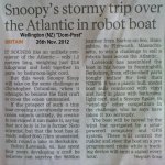
Gadzooks! It's a year later, but look what I've just spotted in todays Wellington (NZ) "Dom-Post" !
Attachments
-
 331.9 KB Views: 46
JimPerry
Senior Member
More detail here and PicAxe (sic) is mentioned - this Saturday is launch date http://www.telegraph.co.uk/news/newstopics/howaboutthat/9700893/Snoopy-Sloop-the-unmanned-toy-boat-attempting-Atlantic-crossing.html#
It's on Yahoo as well:http://news.yahoo.com/blogs/trending-now/unmanned-vessel-seeks-break-world-record-transatlantic-trip-200640786.html
Robin's famous.
Robin's famous.
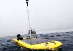
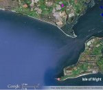
Sadly, Snoopy has crashed on The Needles, Isle of Wight :-( Report here on Robins website http://www.gpss.force9.co.uk/ and satellite track here (while it lasts) http://share.findmespot.com/shared/faces/viewspots.jsp?glId=0xeXvW8cOXyhelJW3qqj1jac49yD6m4ZC I hope that it can be retrieved and repaired, Robin must be gutted.
paulr
paulr
Couldn't see the satellite track but BBC have a course image along with their coverage here -
http://www.bbc.co.uk/news/uk-england-hampshire-20524235
Commiserations to Robin and all involved. Perhaps Snoopy will be rescued and sail again but the odds are perhaps against that. We hope the sad outcome doesn't doesn't detract too much from the adventure which we hope continues.
http://www.bbc.co.uk/news/uk-england-hampshire-20524235
Commiserations to Robin and all involved. Perhaps Snoopy will be rescued and sail again but the odds are perhaps against that. We hope the sad outcome doesn't doesn't detract too much from the adventure which we hope continues.
Robin Lovelock
Senior Member
Hi Folks! Wow! I wished I'd re-visited this thread before ! I was about to ask a question, and start another thread, to ask a question, but perhaps I'll just put the question here, after I've said a few things first. If any of you visit my old page www.gpss.co.uk/autop.htm you will see that since the launch, over a week ago on Tuesday 27th Nov, the page has been updated every few hours, as things happened. There is a link to the BBC TV South News piece that went out in the lunchtime news, while I was drying out at our friends house not far away - you can imagine how we laughed ! Strangly I didn't get cold - maybe it was the adrenylene ? But next time I'll wear my life-jacket - it was a bit hairy getting back ! I was particularly pleased to see that posting by Manuka with the NZ Dom-Post article - since only today, in replying to an "electronic Christmas Card" from friends who have just moved out to NZ for a while (my old boss in Defence Industry is now a Uni. Prof and has gone out there a few months with his wife) I, of course, mentioned our recent fun down on the coast, including with the Radio and TV guys. I'll email them that snoopy.jpg soon! Not much more to say here, beyond what's on my pages above (there is a linked "Searching for Snoopy" page).
Now my question, prompted because I will soon be putting up the design of my boat, so others can donate things like the hull, or rig (sails + mast) so they plug into each other. Some people may choose to use this for their own robot boats, but I expect they will want to do their own thing. The only thing which I'll retain for "Team-Joker" - my local mates like John (see list of "Robin thanks his friends") is the software in the picaxe. Anyone who wants to do their own picaxe autopilot can read these threads and get that same good advice I got from Hippy and others, some of it years ago. But I don't want to give everybody, including competing teams, the actual software that has sailed over 5000 miles on Bray Lake, including it's list of waypoints, that reveal where Snoopy wants to land - to wind-up the Americans !
If somebody finds my boat, or gets a picaxe with some software in it, how easily can you pull the software back out of the picaxe ?
A simple procedure with the picaxe editor ? If they can, what do they get ? Just an exectable program with no comments ?
I'm not that worried about it, but it might be nice to know. Might also be useful if anybody loses their PC backups
Thanks everybody !
Robin
p.s, is there a mechanism for postings to be automatically forwarded to an email address ?
For me that would be robin@gpss.co.uk and any of you are welcome to do that. Taa Muchly as we say in UK
If you used that email address to sign up to the PICAXE Forum, then that will happen if you subscribe to this thread. Select Instant notification by email from the drop down box.p.s, is there a mechanism for postings to be automatically forwarded to an email address ?
For me that would be robin@gpss.co.uk and any of you are welcome to do that. Taa Muchly as we say in UK
inglewoodpete
Senior Member
From the gpss.co.uk website:
Good luck in finding Snoopy. Rest assured, your software is safe.
Love it. Robin is sane, after all!"Robin, despite his name, cannot Tweet."
Good luck in finding Snoopy. Rest assured, your software is safe.
Robin Lovelock
Senior Member
Good Morning Gents ! Thankyou for those quick replies:
Eclectic - Thanks for answering my question - I don't need to worry about another team pinching Team-Joker's software - although they would be daft to use it !
Nick12ab - Thanks for telling me that I should subscribe to the thread. I may do that soon, but not while it's so hectic. Emails cause a claxon to go off here!
Inglewoodpete: Thanks for telling this old man of 65 is not alone in distrusting Twitter (and for me, Facebook). I prefer anonomous graffiti on walls - more artistic.
Manuka - Thanks for that posting with the NZ newspaper article, which is now on my public page www.gpss.co.uk/autop.htm still being updated with latest info.
Perhaps you could send me a private email direct to my robin@gpss.co.uk telling me a little more about yourself such as your street address in Wellington,NZ and - if you still do - where you work. I'm sure my friend near you, mentioned above, won't mind how I've referred to him in my longer posting, and - depending on circumstances - maybe you would both like to be put in touch. No need of course, but it seemed silly for me not to ask.
It seems we have lots of coincidences - starting with Snoopy making an "assault" on that military bunker !
Thanks again everybody, particularly Hippy, for helping in the early years of using the PICAXE.
Robin
Thankyou for those quick replies: Eclectic - Thanks for answering my question - I don't need to worry about another team pinching Team-Joker's software - although they would be daft to use it !
Nick12ab - Thanks for telling me that I should subscribe to the thread. I may do that soon, but not while it's so hectic. Emails cause a claxon to go off here!
Inglewoodpete: Thanks for telling this old man of 65 is not alone in distrusting Twitter (and for me, Facebook). I prefer anonomous graffiti on walls - more artistic.
Manuka - Thanks for that posting with the NZ newspaper article, which is now on my public page www.gpss.co.uk/autop.htm still being updated with latest info.
Perhaps you could send me a private email direct to my robin@gpss.co.uk telling me a little more about yourself such as your street address in Wellington,NZ and - if you still do - where you work. I'm sure my friend near you, mentioned above, won't mind how I've referred to him in my longer posting, and - depending on circumstances - maybe you would both like to be put in touch. No need of course, but it seemed silly for me not to ask.
It seems we have lots of coincidences - starting with Snoopy making an "assault" on that military bunker !
Thanks again everybody, particularly Hippy, for helping in the early years of using the PICAXE.
Robin
Robin, don't feel bad, because I am 38 and have no idea what the Twitter fuss is all about.Thanks for telling this old man of 65 is not alone in distrusting Twitter (and for me, Facebook). I prefer anonomous graffiti on walls - more artistic.
I have no need for the whole world to know when i last wiped my nose!
Sorry to read of the demise of your vessel. Had hoped it would cross the ocean under PICAXE power no less.
News to hand: A "PacX" autonomous wave glider,powered by wave motion,has just crossed the Pacific & landed in Australia OK. See the Press Release ,with technical details here and here. (The budget for this project was of course orders of magnitude greater than for Robin's Atlantic yacht attempt)
Attachments
-
 120.2 KB Views: 17
Last edited:
Robin Lovelock
Senior Member
Hi Folks ! Maybe someone has a specific solution to add a compass to a PICAXE ?
e.g. a particular chip, and means of interfacing it into the PICAXE ?
Maybe exactly as I have the Wind Direction Sensor, with an analogue voltage into a pin ?
If you check my main robot boat page www.gpss.co.uk/autop.htm you can see that,
as we get close to Christmas my priorities have changed, and although Snoopy may be found,
I'm now gathering bits for his next boat, to launch another atttempt in early 2013. Maybe 1st April !
I have a linked "design" page, which describes our existing design, on www.gpss.co.uk/rbdesign.htm
The next boat is planned to be almost identical to the last, including the same version of the PICAXE software.
However, when that boat is finished, and doing it's minimum of a few weeks 24/7 test on Bray Lake,
I can afford time to work on yet another boat, and that might have improvements to the design
- that will also need a long period of testing, before Snoopy risks going to sea in it !
Top of the list - if a suitable solution can be found - is the electronic (fluxgate?) compass.
Here are words, currently on my "design" page pasted in below. Note need for low power drain.
Oh yes, to put all this into perspective, our family newsletter is on www.gpss.co.uk/xmas12.htm
- enjoy the linked video of us dancing, dressed as elves
Robin
www.gpss.co.uk
from design page www.gpss.co.uk/rbdesign.htm >>>>>
Electronic Compass ?
This is not relevant to the existing design, expected to be used for the next boat, but this seemed a good place to put a request for information. It's obvious from my emails, that a lot of technical guys are reading this page. If you go back to my earliest thoughts in 2008, you will see I was thinking of a flux gate compass, to sense where the boat is pointing, for the autopilot steering. Our simple GPS solutions use, instead, the direction the boat is moving - which is not the same thing. Things like the tide can "confuse" the autopilot. We can live with this design limitation if we launch at the right time and place, to avoid the tide taking the boat onto the rocks. Sound familiar ? However, if we wanted to perform a sailing mission such as "sail around the Isle of Wight" - we would need to have an autopilot that would handle the tide better. I think the answer could be an electronic compass.
The problem for adding an electronic (flux-gate?) compass to our design, is that I have some pretty demanding specifications on it, including the low power drain. This is very analogous to the wind direction sensor, that worked, but we removed to reduce total power consumption. These is a link to the details of this on our "list of bits" at the bottom.
I'd be looking for a similar device: it would draw no more than 10mA - less would be better. It would work from a supply of 5v, with a reasonable margin of perhaps +-1v. I assume the simplest way of interfacing it to the picaxe would be the same as for the (removed) wind direction sensor. i.e. it takes it's 5v power from a servo lead and supplies back an analogue voltage corresponding to compass heading (instead of wind speed direction).
I've googled in the past and found technical literature, but not a suitable product, ready to buy and test. Can anyone help ? It would need a software change, so would be subject to all our Bray Lake tests, including the 24/7 one, but it might find it's way into yet another boat launched in 2013 - perhaps after a "round the Isle of Wight" test
p.s. it seems I can get emails now to see these postings more quickly, by using "subscribe".
Last edited:
JimPerry
Senior Member
http://proto-pic.co.uk/compass-module-hmc6352/?gclid=CL2ekKCNobQCFZMftAodkhgAEQ ticks most of the boxes with i2c and 1ma @ 3 Volt
Robin Lovelock
Senior Member
Wow Jim! Just what I needed - and all so fast ! Must edit my p.s. above because I'm getting emails from this thread now
I've even gone ahead and ordered two by paypal - so I can afford to blow up one ! Maybe I will start that v2 of my software soon,
for testing with boat 6, in parallel with working on boat 9 to throw into the sea with Snoopy on it. Many Thanks Jim !
Robin
www.gpss.co.uk/autop.htm
I've even gone ahead and ordered two by paypal - so I can afford to blow up one ! Maybe I will start that v2 of my software soon,
for testing with boat 6, in parallel with working on boat 9 to throw into the sea with Snoopy on it. Many Thanks Jim !
Robin
www.gpss.co.uk/autop.htm
Another low power high sensitive compass module: Freescale MAG3110.
At lower frequency readings (0.63Hz) it uses down to 8.6 uA at around 3V: http://cache.freescale.com/files/sensors/doc/data_sheet/MAG3110.pdf?fpsp=1&WT_TYPE=Data Sheets&WT_VENDOR=FREESCALE&WT_FILE_FORMAT=pdf&WT_ASSET=Documentation
I used it with Picaxe 08M2 with high frequency readings (hence higher power consumption): http://www.picaxeforum.co.uk/showthread.php?21038-MAG3110-I2C-3-axes-sensitive-magnetometer&highlight=MAG3110
SMD chip prices are a few dollars, but they are way too small for me to handle, breakout-boards including soldered MAG3110 are available on ebay for around 15$, and at Olimex for around 10€.
Success
Thierry
Robin Lovelock
Senior Member
Wow! Yet another! Thanks Thierry. I had a quick look, and I must remember to add this, as I have the earlier chip, to bottom of my www.gpss.co.uk/rbdesign.htm page.
Good that you've already done the picaxe interfacing, and at a first glance, it looks like analogue voltage input, like my wind direction sensor.
I hope I've not been too quick in my enthusiasm in ordering those two compass modules after seeing Jim's posting.
I still have the text-to-speech module here, which has been tested, you can hear on one of my videos, but has yet to be put on a boat
I started to look at the data sheet, on that module from Proto-Pic and I see it seems to have a two-way rs232 protocol.
So I guess, when I get it through the post, the question will be how quickly do I get a simple picaxe test program working with it.
Then it will be a question of how easily this "reading of the compass" can be included into the loop of my existing picaxe autopilot
- also described in simple terms on my design page www.gpss.co.uk/rbdesign.htm Then I can get it out on Bray Lake for test.
Looks as if I'd be doing SERIN and SEROUT to the same "servo position" as used for the wind direction sensor, before it was removed.
Right now I use one position with SERIN to get the GPS data, and a second servo position to drive the rudder servo.
If anyone sees how this is done, it may save me some time.
Sorry Thierry, if I don't order that alternative chip yet - but I will put a link to your thread up on my page. I saw your bit about "frying with 5v"
Many Thanks.
Robin
Robin,
No problem at all not using MAG3110, I was just trying to answer your question.
And apart from MAG3110 having 3D readings instead of 2D (so it can detect if mast is upright, downwards, or tilted), lower power cons., being cheaper and faster, the HMC6352 definitely has the advantage of providing the heading-value out of the box. That really is a benefit compared to calculating this from the raw XY(Z) readings.
My main concern with HMC6352's 2D heading readings would be that this device is not tilt-compensated, therefore it needs to be fixed on a level surface for best accuracy, which seems a bit of a challenge on a sailing boat.
It's application notes says: 'each degree of tilt from a level orientation could add two degrees of compass heading error'. Imagine what that means at a mere 20 degrees tilt of the boat.
There are tilt compensated units that provide heading readings, but they are 3-4x more expensive: http://proto-pic.co.uk/categories/Sensors/Magneto/, (hey, and there's the MAG3110 again
Rgds
Thierry
Robin Lovelock
Senior Member
Thanks Thierry and Jim. I'm not too worried about inaccuracy due to tilting, and this would soon show up during our first Bray Lake test in a decent bit of wind. I'd be checking out the GPS plots against the sort you see further down that front page www.gpss.co.uk/autop.htm Don't forget that there is a 6 or 7 second control loop, of reading GPS, (optional wind sensor or compass), then rudder servo control. We might have to "smooth" the compass heading. I'm guessing that, maybe even without smoothing, the average value we get will be good for accurate enough steering. I was very pleased to see our first 2 hours sailing on the sea were a nice straight line within 6 degrees of that 33 mile distant waypoint - much better than we got on Bray Lake. So it's doing that PICAXE serin/serout that may take a bit of time - but hopefully not.
Last edited:
JimPerry
Senior Member
It might be worth considering a second Picaxe (the SMD 08M on a board that Tech Supplies sell?) to read the compass chip and send the calculated reading serially to the first Picaxe - or even more calculation stuff if needed. Would free program space on the existing board.
EDIT: That product has been discontinued
EDIT: That product has been discontinued
Robin Lovelock
Senior Member
Thanks Jim. First I'd better say I was confused earlier by an email of a posting from Martin starting
"I2C interface rather than the requested analogue interface ..." but I guess he deleted it
- probably realised that I know it's I2C (rs232) and we need to use serin/serout.
Jim - I'm hoping just sending something like "A" with SEROUT, then picking up bytes with SERIN,
before using them to get the compass heading, will not be too expensive on memory - or my time
I've not looked at the documentation close enough yet. I hope it's as simple as I hope.
e.g. that text-to-speech chip was just a qestion of sending it text with SEROUT. e.g. "hello, this is Snoopy!"
Robin
www.gpss.co.uk/autop.htm and www.gpss.co.uk/rbdesign.htm more relevant to this thread.
Jim,
That would be the way I would approach it:
This way the GPS unit provides the geo-location and the above 08M2 provides the orientation, very much like a modern smartphone with Google Skyview
Thierry
That would be the way I would approach it:
- 3D Accelerometer with I2C (eg MPU-6050 or MMA7660 or MMA7260)
- 3D Magnetic Field sensor with I2C
- separate 08M2 doing the calculations of Magnetic XYZ plus the Gravity XYZ into Heading+Tilt+Pan plus as by product, some alarms? (boat upside down, boat heading straight up, meaning very high waves, maybe even the height of the waves...)
- the 08M2 sends it's data via serial signal to central unit, easy to develop and debug as a standalaone unit
This way the GPS unit provides the geo-location and the above 08M2 provides the orientation, very much like a modern smartphone with Google Skyview
Thierry
If you're talking about the proto-pic board (an I'm confused about whether you are or not) then I2C is not RS232/SERIN/SEROUT comptaible. You would have to use the PICAXE I2c commands- probably realised that I know it's I2C (rs232) and we need to use serin/serout.
Jim - I'm hoping just sending something like "A" with SEROUT, then picking up bytes with SERIN,
If you're talking about another PICAXE to "hide" the proto-pic's I2C interface behind a PICAXE->PICAXE set of comms, then you could use serial (serin/serout) commands.
FYI, I2C is often called a serial protocol as the data is presented serially on the I2C data bus - but it's not RS-232 or serin/serout compatible serial
Robin Lovelock
Senior Member
Thanks Martin - Oh Dear! It does look as if my enthusiasm got the better of me this morning, and ordering those two modules. If you look further back on this rather long thread - or my page www.gpss.co.uk/rbdesign.htm you will probably see that I'm using the PICAXE servo controller board in these autopilots. I must admit I'd assumed - perhaps wrongly - that the module was a serial interface, and it just needed the correct byte (e.g. an "A") sent to it, before it sent back a string of bytes holding the magnetic heading. i.e. much simpler than what I'm already doing to extract data from the GPS, such as lat/lon, speed and direction of travel. If I was mistaken Martin - you've just saved me a lot of time - so thanks !
No worries Robin,
The protocols I2C and serial/RS232 may be different, but even the smallest Picaxe 08M2 supports I2C and serial out of the box, and there's plenty support on this forum to develop a setup with a 2nd 08M2 doing the I2C stuff with one or multiple I2C sensors and respond to the main Picaxe in a way you want, even responding to an "A" with the required orientation data over serial pins, or, as Jim is suggesting, to combine it all in one Picaxe if that saves power, space, money, ...
Rgds
Thierry
JimPerry
Senior Member
Nooooo - 2 Picaxes - 1 board (eventually)No worries Robin,
or, as Jim is suggesting, to combine it all in one Picaxe if that saves power, space, money, ...
Jeremy Harris
Senior Member
I know you binned the idea of a wind direction sensor earlier, because of the high current consumption, but it is worth noting that a magnet fitted to a wind vane that is positioned over a 2 axis Hall magnetometer will give a pretty good low power wind direction sensor. I used the technique a few years ago and found it was OK for accuracies of around 5 deg or so. The newer Hall magnetometers are probably a fair bit better now.
Robin Lovelock
Senior Member
Good Morning Gentlemen ! As always, my robot boat front page on www.gpss.co.uk/autop.htm says the important things for me right now. e.g. getting reliable data on tidal current so we know the design limitation of our present GPS-based design, and can make sure our time of launch is safe from effect of the tide.
But, right now this thread talks about a design change, involving adding a compass. The design page is www.gpss.co.uk/rbdesign.htm
This change needs some time to test properly: at least a few weeks, just for final testing. Maybe we will have it later in 2013 - for the boat after next, or boat after that.
I can report a very good experience yesterday with RelChron Ltd / Proto-pic, and this may lead to an even simpler and better solution from them. A few hours after I did my "too hasty" order and paypal payment, I sent them an email, explaining my mistake and the background. Imagine my delight when a director, checking his emails at home said he's "put a hold" on the order, and a "technical geru" would call me the next day. This chap did, another director, and we had a long and interesting conversation, including about products that might be interfaced directly to my picaxe servo driver board. My paypal payment was refunded, and I'm sure there will be more information here, in the months ahead, leading to my adding a compass to our solution.
Now to advance the discussion: to my view, assuming we don't have a product that can be used simply with picaxe serin (or analogue, as the wind direction sensor) we need a simple "sub-sub-system". Maybe as Jim suggested, based on that same Proto-pic product and a different picaxe board that does support the protocol.
This board should handle the compass, giving it whatever it needs, such as an "A" to initiate passing back compass heading. This data should be passed
back via serout to to the Autopilot picaxe which simply does a regular serin to read the data - preferably in a simple format. e.g. "H090"
- or even the standard NMEA format - if the maker wants to sell the product elsewhere.
From what's been said on this thread already, this sounds like a simple task - maybe someone will even post the required code for the program here ?
Or even build a prototype ? Remember that when considering the total system reliability, one should consider things like what happens
when power goes down and comes back up again. But things like this will get tested anyway, before it goes to sea.
If this were done, then maybe the picaxe autopilot software (version 2) would support this device. e.g. if it receives the compass data it will use it.
If no data is coming in (a timeout on the serin) then it uses the GPS direction of travel, as now. i.e. the design can tolerate a compass failure.
Before rushing in to worry about "tilt" on the compass - remember KISS.
KISS = Keep It Simple, Stupid !
Robin
www.gpss.co.uk
Robin
Looking at the devices that Proto-Pic is selling, there seems 1 unit that could do what you require even without an extra Picaxe device, because it also provides Tilt compensated Heading as serial data output or as I2C interface, ie. CMPS10 . Example application with Picaxe here.
Main downside seems the 25mA current it draws, but perhaps it can be put to sleep most of the time? Can't find that in the specs, but you can always have the 'master'-Picaxe completely switch the Power of this module on/off through a transistor.
Alternatively the LSM303 provides all the ingredients (3D magnetometer plus 3D accelerometer, I2C interface, <1mA), but this will need some interfacing MCU like a Picaxe plus some advanced trigonometry maths to convert these 6 dimensions into a tilt compensated heading over a serial interface, see also here. Seems mote fun than a CMPS10, but I'm not sure if this math fits the KISS bill.
Thierry
Robin Lovelock
Senior Member
Thanks Thierry. Dramatic news now on www.gpss.co.uk/autop.htm - it seems someone in a kayak "stole" Snoopy then took him, AGAINST THE FLOW OF THE TIDE, to near The Needles. So this changes our design-change priorities. But thanks - that product could be very useful Thierry. I see you are in Holland, where I worked for ten years in the 1970s. Tot Ziens !
Robin
www.gpss.co.uk
Robin
www.gpss.co.uk
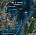
Sacre bleu! Do you mean out of sight around the Needles cliffs, or mid channel? Distances weren't great so surely you were following progress with binoculars from the launch site? As a comparison traffic lights across our local 10km wide Wellington Harbour can be readily seen unaided in twilight conditions, & (by day) binoculars allow small kayaks etc to be easily followed from the beach to at least our nearby Ward Island ~2km offshore. We admittedly however usually have very clear air here.
I used to live coastal West Sussex & recall Channel & Solent conditions well -unless someone was forewarned & determined, wouldn't casual sea kayaking at twilight (~4:30-5pm at launch date) be a tad hazardous this time of year? Even given the areas complex tides,that quoted 1.5 knots paddling speed is pretty tame too.
Extra -as extreme barometric pressures (high or low) influence Solent tides, what was the local Atmospheric Pressure on 27th November?
Attachments
-
 47.8 KB Views: 17
 -
 69.4 KB Views: 16
Last edited:
Against a 1.8 knot tide, that would be a paddling speed of 3.3 knots .....That quoted 1.5 knots paddling speed is pretty tame as well
And I wouldn't think of venturing out in a 20 knot wind! Or trying to tow a model sailboat towards the Needles.I used to live coastal West Sussex & recall Channel & Solent conditions well -unless someone was forewarned & determined, wouldn't casual sea kayaking at twilight (~4:30-5pm at launch date) be a tad hazardous this time of year?
Nice conspiracy theory, but equally likely it was the Russians chasing Robins thinly disguised NATO spy boat
.