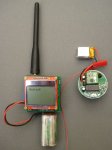
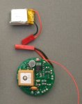
Its working, PONGSAT GPS beacon tracker, LOS range at 10mW around 12kM to receive the GPS tracking information as data telemetry, 50kM or so to receive as fast Morse.
PICAXE 28X2, RFM22B, remote servo driven balloon release, 128kbyte EEPROM storage for logging, DS18B20 temperature sensor, TC54 power supervisor, battery for GPS allows hot start so it can be mostly turned off to conserve power, fits in a ping pong ball. Weight with 150maHr Lipo battery 20g.
If you connect up a yagi to the ground station transmitter, you should be able to release the balloon with the servo from LOS 120kM or so.
The software extracts time, location and altitude from the $GPGGA sentence, then the speed and course from the $GPVTG sentence.
The GPS location, altitude, speed, course, distance and direction from home, temperature, battery, status and run time are transmitted as a data packet which the ground station picks up and displays on the LCD, logs to its serial terminal and also sends output to a OpenLog logger.
For use without the ground station, the distance and direction from home (up to 65km) is transmitted as slow (human readable) Morse. The full Latitude, Longitude and distance and direction from home are transmitted as 120WPM Morse which can be decoded with a UHF transceiver and a PC.
The 128kbyte EEPROM is working, I need to add some code to log the location information to this EEPROM for later printing out.
Now, where is that helium .....
Attachments
-
57.5 KB Views: 136
-
17.3 KB Views: 122
Last edited:


