Robin Lovelock
Senior Member
Many Thanks Hemi345 - I'll check this out. It's from Spark-Fun and could be compatible with what I've been testing. Let's hope it's not using the discontinued product. I had started playing around with the idea of a small mechanical gimbal, but I don't think I can afford the time on it. A picture is now on my "design" page www.gpss.co.uk/rbdesign.htm or direct on www.gpss.co.uk/rbgimb1.gif I'll upload it here ...
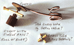
P.S. Jeremy: I like your ideas, such as filling the gimbal container with oil - I'd probably raid the kitchen for cooking oil") The 4 wires from the compass are the real challenge - avoiding metal fatigue during months at sea, preceded by months of 24/7 tests on Bray Lake. One might start with just one axis, to counteract the roll of the boat, which will be big, as it leans over in the wind. The pitch on Bray Lake, with much smaller waves will not be so significant, and one might start with tests to confirm this use of a compass for steering, compared with GPS heading, is worth the effort. My picture shows what I was thinking about: bits of brass tube, soldered together, and all made as small and light as possible. It is only the compass board that needs to be level. But I'd rather avoid the Gimbal all together: let's hope that other product is available - and not completely different to what we have working now.
The 4 wires from the compass are the real challenge - avoiding metal fatigue during months at sea, preceded by months of 24/7 tests on Bray Lake. One might start with just one axis, to counteract the roll of the boat, which will be big, as it leans over in the wind. The pitch on Bray Lake, with much smaller waves will not be so significant, and one might start with tests to confirm this use of a compass for steering, compared with GPS heading, is worth the effort. My picture shows what I was thinking about: bits of brass tube, soldered together, and all made as small and light as possible. It is only the compass board that needs to be level. But I'd rather avoid the Gimbal all together: let's hope that other product is available - and not completely different to what we have working now.
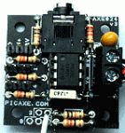
I took a quick look at the data sheet for this other product, and it seems it has no relationship with the Honeywell products, including the one that has been discontinued. It seems to be made by STMicroelectronics, a French-Italian company. I see they have a sales office near me, in Marlow. The data sheet confirms this is low power - well below 1mA, but lower supply voltage of about 3.6v. However, they do say it could survive 4.8v, and so a simple use of diodes could probably power it safely from the same PICAXE AXE024 5v supply. The big problem looks to be software: I reckon it would take someone a lot longer to reach the stage that we did with the HMC6352-AXE024 solution.
p.p.s. Thanks folks, for postings down to Jeremy's #367 below, suggesting the thin enameled copper wires. Good to see that 5v power is not a problem at all, but it does look as if software on the picaxe is a major one. I'll probably finish that little gimbal I started, so I should then be able to use the HMC6352 that I have working, to evaluate if there is any merit in using a compass for steering. If not, there is little point in investing time and effort in a tilt-compensated one.
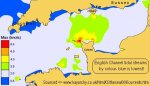
Yet another snag pointed out earlier by Jeremy: the size of the error between magnetic and true north. i.e. "declination" error. It seems this is in the ballpark for UK of about -1.5 but, as one crosses the Atlantic, it gradually increases to about 15 degrees. Checkout http://magnetic-declination.com/ to see current values. Our GPS is providing "true north" and that is what we are using in our autopilot. I wonder how many guys working on Microtransat realize how much simpler a purely GPS based autopilot can be ?
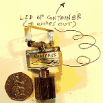
Here's a bit more progress on the gimbal "innards", made from soldering together bits of brass. Both axis swing up to 90 degrees, but will be less after it is put into a small container.
For those into calculating compass heading from X,Y,Z, my friend over the road sent me this link below. Just 6GBP inc. postage, and from Freescale Semiconductor. The I2C MAG3110 3-Axis Digital Compass Magnetometer Module (arduino compatible). http://www.ebay.co.uk/itm/120932896867?ssPageName=STRK:MEWAX:IT&_trksid=p3984.m1423.l2649
The compass gimbal is finished, and you will see a picture on my "design" page, with a few words. You can go direct to the picture on www.gpss.co.uk/rbgimb3.gif
Robin
www.gpss.co.uk/autop.htm - Robin's "front" page.
www.gpss.co.uk/rbdesign.htm - "design" page, including compass near end of page.
P.S. Jeremy: I like your ideas, such as filling the gimbal container with oil - I'd probably raid the kitchen for cooking oil
The 4 wires from the compass are the real challenge - avoiding metal fatigue during months at sea, preceded by months of 24/7 tests on Bray Lake. One might start with just one axis, to counteract the roll of the boat, which will be big, as it leans over in the wind. The pitch on Bray Lake, with much smaller waves will not be so significant, and one might start with tests to confirm this use of a compass for steering, compared with GPS heading, is worth the effort. My picture shows what I was thinking about: bits of brass tube, soldered together, and all made as small and light as possible. It is only the compass board that needs to be level. But I'd rather avoid the Gimbal all together: let's hope that other product is available - and not completely different to what we have working now.Thanks Jeremy (below) but no point in sending me that gimbal. If I did try one, it would probably be much smaller and just to confirm compass-based steering was worth looking at further.I might have missed mention of this, but have you seen this LSM303DLMTR Breakout Board - Tilt Compensated Compass
I took a quick look at the data sheet for this other product, and it seems it has no relationship with the Honeywell products, including the one that has been discontinued. It seems to be made by STMicroelectronics, a French-Italian company. I see they have a sales office near me, in Marlow. The data sheet confirms this is low power - well below 1mA, but lower supply voltage of about 3.6v. However, they do say it could survive 4.8v, and so a simple use of diodes could probably power it safely from the same PICAXE AXE024 5v supply. The big problem looks to be software: I reckon it would take someone a lot longer to reach the stage that we did with the HMC6352-AXE024 solution.
p.p.s. Thanks folks, for postings down to Jeremy's #367 below, suggesting the thin enameled copper wires. Good to see that 5v power is not a problem at all, but it does look as if software on the picaxe is a major one. I'll probably finish that little gimbal I started, so I should then be able to use the HMC6352 that I have working, to evaluate if there is any merit in using a compass for steering. If not, there is little point in investing time and effort in a tilt-compensated one.
Yet another snag pointed out earlier by Jeremy: the size of the error between magnetic and true north. i.e. "declination" error. It seems this is in the ballpark for UK of about -1.5 but, as one crosses the Atlantic, it gradually increases to about 15 degrees. Checkout http://magnetic-declination.com/ to see current values. Our GPS is providing "true north" and that is what we are using in our autopilot. I wonder how many guys working on Microtransat realize how much simpler a purely GPS based autopilot can be ?
Here's a bit more progress on the gimbal "innards", made from soldering together bits of brass. Both axis swing up to 90 degrees, but will be less after it is put into a small container.
For those into calculating compass heading from X,Y,Z, my friend over the road sent me this link below. Just 6GBP inc. postage, and from Freescale Semiconductor. The I2C MAG3110 3-Axis Digital Compass Magnetometer Module (arduino compatible). http://www.ebay.co.uk/itm/120932896867?ssPageName=STRK:MEWAX:IT&_trksid=p3984.m1423.l2649
The compass gimbal is finished, and you will see a picture on my "design" page, with a few words. You can go direct to the picture on www.gpss.co.uk/rbgimb3.gif
Robin
www.gpss.co.uk/autop.htm - Robin's "front" page.
www.gpss.co.uk/rbdesign.htm - "design" page, including compass near end of page.
Last edited: